TAMPA, Fla. — In the wake of Hurricane Helene leaving behind damage across the Southeast, another powerful storm is in the Gulf of Mexico and closing in on Florida.
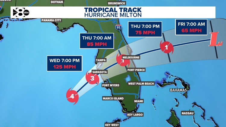
Hurricane Milton, now a Category 3 hurricane, has the potential to be one of the most destructive hurricanes on record for west-central Florida. A projected landfall on Florida's Gulf Coast is expected Wednesday evening around 8 p.m. -9 p.m. as a major hurricane.
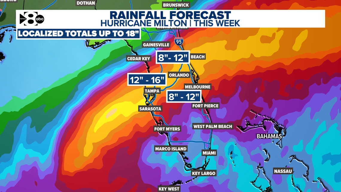
Below are the latest updates on Hurricane Milton, including its path, updated forecast, spaghetti models, and storm surge potential.
Hurricane Milton live radar
Where is Hurricane Milton?
Milton formed in the western Gulf of Mexico early Saturday afternoon. Then underwent rapid intensification Monday morning. It quickly gained Category 5 strength. It'll keep its major hurricane (category 3 or higher) status as it approaches Florida's west coast.
Milton is the second Category 5 storm this season. Hurricane Beryl was the first. Milton joins Michael as the only Category 5 storm in October in the Gulf on record and is the strongest hurricane in the Gulf of Mexico this late in the season. The minimum pressure was below 900 MB making it the strongest Gulf hurricane since 2005 (Wilma).
Florida will see the brunt of this next storm. Milton will encounter wind shear as it gets closer to Florida's west coast. This could knock it down to a Category 4 right before landfall. However, destructive storm surge, damaging winds, and flooding rain will all be likely for the central part of Florida. People in the path should NOT think a lowering in category or wind speed will mean that impacts will be any less.
What time will Milton hit Florida?
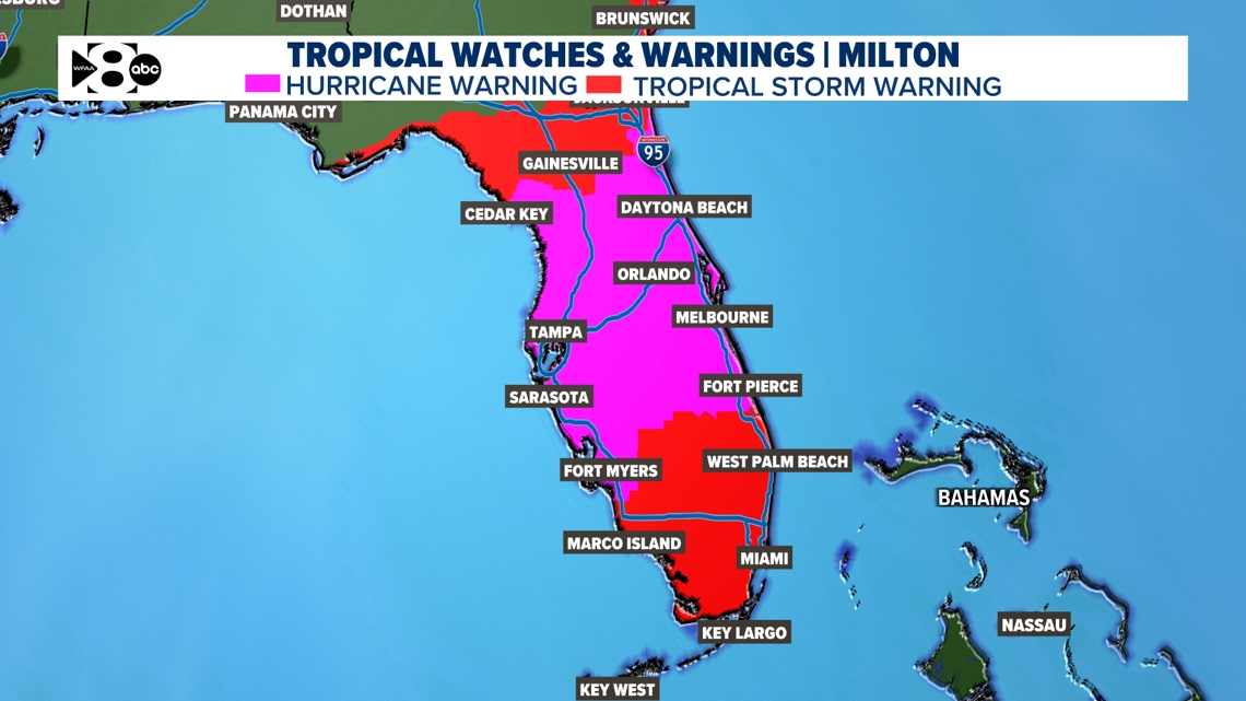
As of Wednesday morning, Milton's landfall is expected to happen between 8 p.m. and 9 p.m. Landfall is when a tropical system's eye crosses the coastline. Impacts will be felt well ahead of landfall. Landfall is expected just south of Tampa near Sarasota.


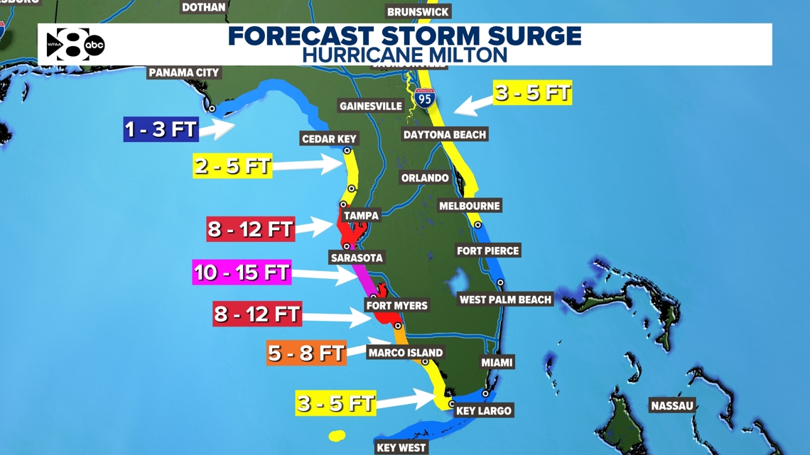
Where the center of the storm makes landfall will affect where storm surge will be highest along the western coast of Florida. Areas on the right-hand side of the track will experience the worst of the storm surge and flooding. However, most of the central coast of Florida will see very destructive storm surge.
Areas well inland will see significant impacts from Milton as well. Winds will topple trees and cause power outages across Central Florida. Heavy rainfall will also contribute to flooding for inland Florida as well.
Of course, this means areas still recovering from Helene (Tampa Bay and other areas along the western coast of Florida) could see more trouble while still trying to clean up. However, this storm will NOT affect most of Georgia, Tennessee, and The Carolinas still recovering from Helene.


Is Hurricane Milton going to hit Texas?
The short answer is no.
A much larger weather pattern is helping guide Milton toward Florida and away from Texas. The cold front at the beginning of this week plays a huge part in keeping any tropical activity away from Texas this week. It is also the same system that will help bring Milton down a category ahead of landfall.
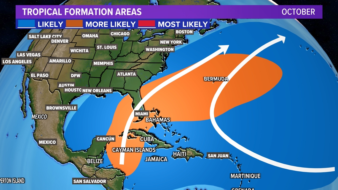
October typically does not bring much tropical activity to Texas. Only 6 hurricanes or tropical storms have made landfall in Texas during October on record (records go back to the 1800s).
The overall pattern usually doesn't favor significant tropical systems moving into Texas.
Milton is occurring in a very common area for October. Favored areas of formation are in the southern/western Caribbean, eastern Gulf of Mexico, and off the East Coast of the U.S. And usually tracks are north/northeastward from that point.