

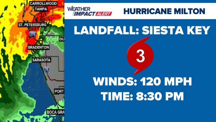
TAMPA, Fla. — Hurricane Milton made landfall just after 8:30 p.m. on Florida's Gulf Coast as a Category 3 storm. It has since weakened to a Category 1 hurricane as it continues to move across Florida. As of the latest advisory, forecasters say Milton is at Florida's east coast and is close to leaving the state entirely.
According to the National Hurricane Center, it continues to bring devastating rains and damaging winds inland over parts of central Florida.
Milton came on the scene on Saturday as a tropical storm. Early Monday morning, Milton kicked off a rapid intensification starting as a Category 2 storm. It waffled between Category 4 and 5 strength on Tuesday before weakening to a Category 3 on Wednesday.
As of the 5 a.m. advisory, the storm is about 10 miles northeast of Cape Canaveral. It's moving east-northeast at 18 mph with maximum sustained winds of 85 mph.
A hurricane warning is in effect for:
- Florida east coast from the St. Lucie/Martin County Line northward to Ponte Vedra Beach
A hurricane watch has been issued for the following:
- N/A
A tropical storm warning is in place for:
- Florida east coast south of the St. Lucie/Martin County Line to the Broward/Palm Beach County Line
- North of Ponte Vedra Beach Florida to Edisto Beach South Carolina
- Extreme northwestern Bahamas, including Grand Bahama Island, the Abacos, and Bimini
A storm surge warning is in effect for:
- Florida west coast from Bonita Beach northward to Middle of Longboat Key, including Charlotte Harbor
- Sebastian Inlet Florida to Altamaha Sound Georgia, including the
St. Johns River
Hurricane Milton's path resulted in lower storm surge totals for the Tampa Bay area. However, parts of Pinellas County saw around 17 inches of rainfall in a short period of time, leading to flooding.
A flood emergency was issued for parts of the Tampa Bay area due to rainfall and fresh-water flooding.
Originally, NHC forecasters believed the Tampa Bay area could see 6 to 9 feet of storm surge as Milton moved across the area. The Sarasota-Bradenton area was expected to see 9 to 13 feet of storm surge.
Rainfall from Milton was expected to range between 5-12 inches with localized totals up to 18 inches across portions of the Florida Peninsula and the Keys through Wednesday night. That rainfall will bring risks of flash, urban and areal flooding along with minor to moderate river flooding, according to NHC.
Our 10 Tampa Bay Weather team will continue to monitor any development and keep you informed, prepared and connected through the rest of hurricane season.