


HUNTSVILLE, Ala. — Dropsonde data from an Air Force Reserve reconnaissance aircraft and NOAA buoy 42055 in the southwestern Gulf of Mexico indicate that the system has developed a well-defined center of circulation. In addition, deep convection has formed near the center, as well as within a band extending 200 n mi to the southeast of the center. This convection is classifiable via the Dvorak technique. The system meets the necessary requirements of being a tropical cyclone and is therefore being designated as Tropical Storm Alberto. Aircraft and surface observations suggest the maximum winds remain about 35 kt, but the central pressure has dropped to about 995 mb according to the dropsonde data. Some of the dropsonde and oil rig data in the northwestern Gulf indicate that stronger winds are located not too far above the ocean surface, but the environment appears too stable for sustained winds of that magnitude to mix efficiently down to the surface. Still, this could mean that gusty winds affect much of South Texas as the convective activity moves inland through the day.
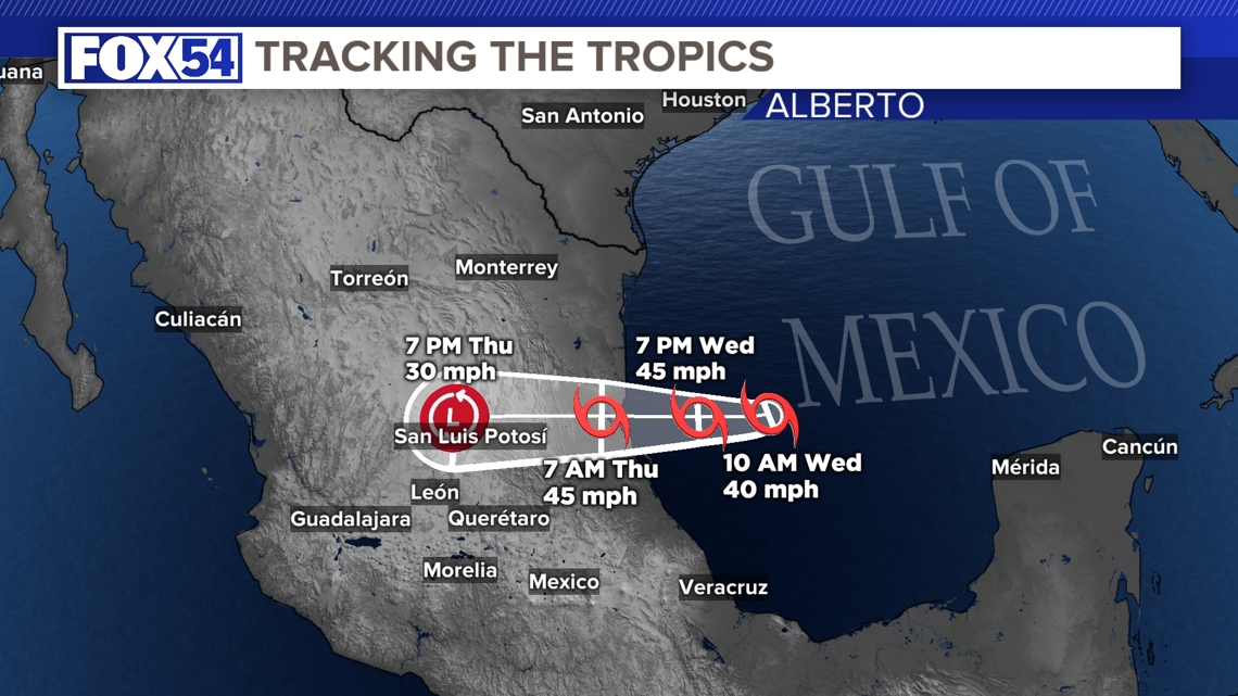
Alberto may have jogged a bit south now that a more defined center has become apparent, but the general motion remains westward, or 270/8 kt. This westward motion is expected to continue for the next day or two while mid-level ridging over the eastern U.S. builds westward, and the track models all agree that the center of Alberto should be inland over northeastern Mexico by this time Thursday morning.
Alberto has a chance to strengthen within a favorable environment of low vertical shear and warm sea surface temperatures of about 30 degrees Celsius. However, the broad circulation will still likely limit the amount of strengthening that can occur, and the NHC forecast continues to show a peak intensity of 40 kt before the storm reaches land. There is some possibility of slight strengthening beyond that level, as suggested by the GFS and HAFS-B models. After landfall, rapid weakening is forecast on Thursday. A 36-hour forecast point as a remnant low is shown mostly for continuity, but in all likelihood the system will have dissipated over the mountainous terrain of Mexico by then.
Regardless of Alberto's exact track, this system will have a large area of heavy rains, moderate coastal flooding and tropical-storm-force winds well north of the center. Importantly, the official wind speed probabilities are likely underestimating the chances of tropical-storm-force winds along the Texas coast because of the unusually large and asymmetric area of strong winds on the northern side of the circulation.
Key Messages:
- Users are reminded not to focus on the exact forecast track of this system. Alberto is very large with rainfall, coastal flooding, and wind impacts likely to occur far from the center along the coasts of Texas and northeastern Mexico.
- Heavy rainfall associated with Tropical Storm Alberto will impact large regions of Central America, north across northeastern Mexico and into South Texas. This rainfall will likely produce considerable flash and urban flooding along with new and renewed river flooding. Life-threatening flooding and mudslides are likely in and near areas of higher terrain across the Mexican states of Coahuila, Nuevo Leon, and Tamaulipas, including the cities of Monterrey and Ciudad
Victoria. - Moderate coastal flooding is likely along much of the Texas Coast through Thursday
- Tropical storm conditions are expected today along portions of the Texas coast south of San Luis Pass and along portions of the coast of northeastern Mexico within the Tropical Storm Warning area.