
Anyone with the smallest knowledge and basic understanding of meteorological definitions will agree when I say I cannot write a whole blog on stationary fronts. It’s a good thing I’m not planning to write a whole blog on stationary fronts. Instead today’s blog will discuss the definition of the front(which is pretty self-explanatory) and then how that front is impacting our weather on the local scale here in the Tennessee Valley.
So what is a stationary front? Well at its simplest and only terms a stationary front is a front that is stationary. Honestly I don’t think it can get much simpler than that. Stationary means not moving and a front is a separation of two air masses. If that’s all you wanted out of this blog you can stop reading now.
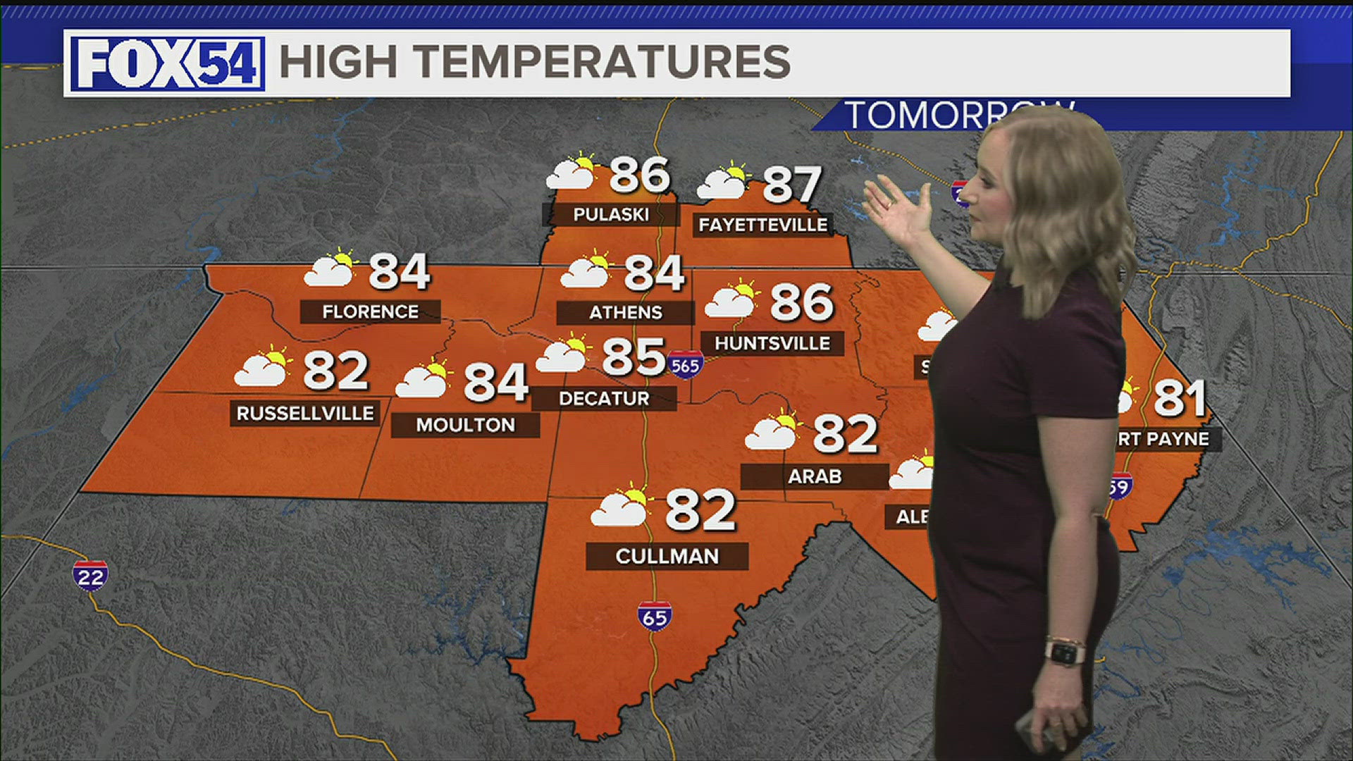
As discussed in this morning’s forecast video, the likelihood of finding yourself under a scattered shower this afternoon will increase the further east you go of I-65. That’s because the front itself is cutting the Tennessee Valley in half.
On the forward side we have a more moist air mass, and on the back side we can see a more dry air mass. That is made incredibly obvious by looking at the Water Vapor Satellite imagery above. There is a clear divide between the more moist air mass and then the drier air mass across NW Alabama. We’ll stick with this pattern through the middle of the day tomorrow before we begin to see some changes. In the meantime it also means folks across NW Alabama will likely warm up more in the afternoon because they’ll see more sunshine as opposed to those of us on the forward side of the front who have to deal with more cloud cover.
Over the next couple days, especially Friday and into the weekend we’ll begin to see some changes involving the high pressure system currently into the Atlantic. It’ll move south a bit and strengthen. Over time this high will also push to the east getting close to the east coast. This will change our direction of flow to more of a southeasterly pattern. As that happens we’ll see humidity values increase, but our temperatures will also rise. This is a bit of the ridge of death pattern I mentioned in yesterday’s blog. What that means is that the weekend is looking good aside from a few possible afternoon and evening pulse storms.